John Betts - Fine Minerals > Home Page> Educational Articles > Minerals of South Glastonbury, Connecticut |
by John H. Betts, All Rights Reserved
This web page is provided as a resource to mineral
collectors.
Contact the property owner before entering the property to obtain written
permission to collect minerals.
John Betts does not own this property and he cannot
grant permission to enter the site.
From the north end of the Howe No. 1 quarry a trail, to the northeast, connects to the old Griswold Quarry. Stugard (1958) mapped this quarry as number 65. No apparent collecting has been done here in recent times. The overgrown dumps are visible on the north side of the "T" intersection where this trail meets the old woods road that leads back towards Dayton Road.
|
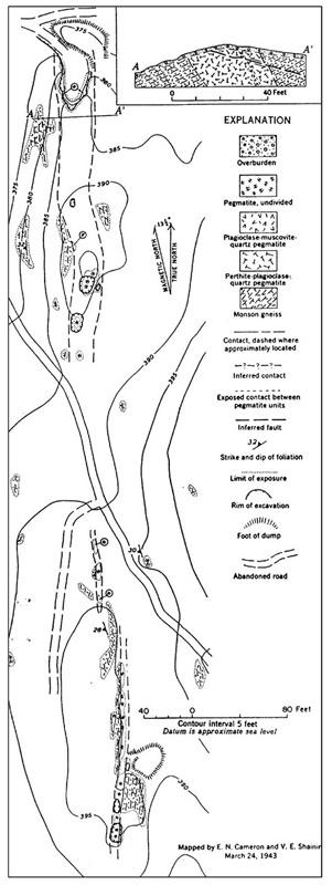
Figure 18 - Map of the Hollister quarry, north and south pegmatites (from Cameron et al., 1954). |
The Hollister quarry (Stugard pegmatite 69) is reached by starting at parking location B (fig. 2). An abandoned mine road extends south to the quarry. The northern open-cut and dumps are about 15 yards into the woods east of the trail. The southern excavation is 400 yards beyond, on the west side of the trail.
Cameron et al. (1954) reported that the quarry was worked briefly for feldspar around 1930. Subsequently it was worked for several months during World War II (1943) for feldspar and muscovite mica by a gentleman named Fausto Bertolini. The property was mapped by Cameron and Shainin at this time (fig. 18). They divided the site into the north and south pegmatites, and consisting of seven small excavations in three visible pegmatite exposures that strike due north. The three exposures, as mapped by Cameron et al.(1954), may be connected at depth.
The north pegmatite dips steeply eastward and is exposed for 240 by 25 feet. This pegmatite is roughly parallel to the strike of the wall rock foliation but differs markedly in dip. The quarry excavation is 65 feet long, 20 feet wide, and 15 feet at maximum depth. This pit is currently filled with water making inspection or collecting difficult.
Most of the pegmatite consists of quartz, perthite, graphic granite, and plagioclase in varying proportions, with accessory muscovite, spessartine, elbaite, schorl, beryl, and columbite-tantalite. During mining, muscovite books were found ranging in size up to12 inches in diameter and 4 inches thick. The muscovite shows a grating-type stain, forming a reticulated internal pattern, probably due to magnetite inclusions.
Casual inspection of the north dump showed obvious mineralization of interest to collectors. Beryl, associated with quartz and plagioclase, was found scattered throughout this pegmatite in blue-green to green to yellow-green crystals, mostly less than one inch long. However, crystals as large as 2 inches in diameter and 4 inches long have been found here in the past. Cameron et al.(1954) measured the exposed surface area of 80 beryl crystals over 142.9 square feet of exposed headwall and estimated the beryl content to be 0.09 percent. Some of the best crystals of microlite found in this area occur at the Hollister, up to 1 inch diameter.
The north quarry is presently part of the property of the adjacent home that overlooks the site to the west.
The south pegmatite is exposed for 160 feet and varies in width between 4 and 9 feet. Quarrying occurred on the eastern flank of the pegmatite resulting in an 80 foot long cut (fig. 19). The pegmatite consists of smoky quartz, perthite, massive plagioclase, cleavelandite, garnet, beryl and traces of lepidolite and columbite-tantalite. Beryl crystals as large as 2 inches in diameter and 5 inches long have been found associated with quartz and cleavelandite and are unevenly distributed throughout the pegmatite. Measurement of the exposed beryl indicates 0.11 percent beryl content in the pegmatite. Microlite (Figs. 20 and 21) has been found here up to one inch diameter, though undamaged specimens rarely exceed half inch diameter (Fast 1997, pers. comm.). Other noteworthy minerals include elbaite, cassiterite, manganapatite, gahnite, samarskite-Y, spessartine, and gemmy blue-green beryl. The Hollister quarry has received more attention from collectors than nearby locations. It is unclear if this was because it has better mineralization or because it was a published locality and access was permitted.
The present owner of the south quarry is unknown to the author. However, collectors have recently reported that this site is now posted with "No Trespassing" signs. Please respect the landowners rights.
|
|
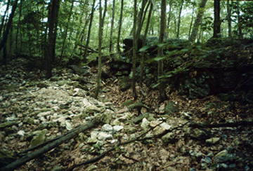
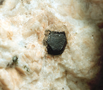
| Figure 19 - The southern excavation at the Hollister quarry in 1996. | Figure 20 - Sharp complex crystal of microlite one half inch across in albite from the Hollister quarry collected by Richard Schooner. Wesleyan University Natural History Museum Collection No. 13803. |
The southernmost quarry in the region, the Simpson quarry (Stugard pegmatite 80), is reached from parking location C (fig. 2). There is a trail extending north from the road. This is the old East Road (sometimes called Dayton Road on town maps), an abandoned carriage road, (often shown in out-of-date collecting guides running north from the intersection of Isinglass Hill Road and Thompson Hill Road and continuing past the Simpson quarry to Dayton Road). Two hundred and fifty yards north of the parking area, at the point where the trail breaks to the right, a foot long white rock has been placed as a trail marker. As of June 1996 there were orange ribbon trail markers from this point on tree limbs marking a rough path to the Simpson quarry. The markers were placed there by Ed Force of the Bristol Mineral Club (Force 1996, pers. comm.) for use by members on their field trips. Even with the trail markers it is rough bushwhacking, along a general bearing of 280º, to get to the overgrown quarry dumps.
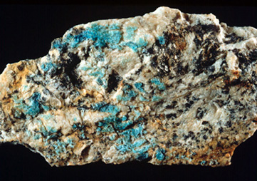
The quarries are two adjacent cuts in a pegmatite striking approximately 20º north with large dumps to the east. There are other small prospects to the northwest in the woods, but collectors do best by digging in the dumps. Top-quality aquamarine beryl has been found here by collectors in the past. Opaque blue-green beryl crystals up to 4 inches diameter can be found in the quarry walls. Bright blue-green hyalite opal has been found here and is highly prized by collectors (Fig. 22). Almandine, autunite, columbite, elbaite, gahnite, lepidolite samarskite-Y, spessartine, and uraninite has been reported from this quarry.
One word of caution, snakes have been reported deep in the dumps by collectors digging at this quarry, collectors should use caution when digging (R. Sinclair 1996, pers. comm.).
Double I, LLC owns about 100 acres of land in Glastonbury on which the Simpson Quarry is located. The property is not being developed. Collectors are welcome to visit the site as long as they don' leave trash behind. There are snakes in the area as it is part of the habitat of the Eastern Timber Rattlesnake, an endangered species in Connecticut.
|
|
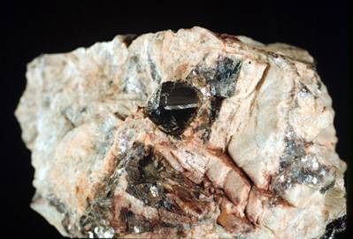
| Figure 21 - Microlite from the Hollister quarry, South Glastonbury, Connecticut, collected by Richard Schooner and Peter Leavens. Peabody Museum of Natural History, Yale University Specimen no. 4223. Photo by William Sacco. | Figure 22 - Blue hyalite opal from the Simpson quarry, south Glastonbury, Connecticut. Collected by R. Behnke. Wesleyan University Natural History Museum Collection No. 13891. |
Many minerals have been found in the area covered by this article. The compiled mineral list is based on Schairer (1931), Hiller (1971), Jarnot (1989), Weber and Sullivan (1995). Several recent discoveries of mineral occurrences were contributed by prolific field collectors Richard Schooner, Edward Force, Jeff Fast, Anthony Albini, Rick Sinclair, and Steve Stieglitz.
Specimens dating back to 1905 collected by Samuel L. Penfield (1856-1906) and Hurlburt are in the collection of the Peabody Museum of Natural History at Yale University and in the Natural History Museum of the Department of Earth & Environmental Sciences at Wesleyan University.
The following lists known mineral occurrences at each quarry:
Albite, Allanite, Almandine, Autunite, Beryl, Biotite, Bismutite, Cassiterite, Columbite, Elbaite, Epidote, Gahnite, Lepidolite, Manganapatite, Microcline, Microlite, Molybdenite, Monazite, Muscovite, Opal, Pyrolusite, Pyrite, Quartz, Samarskite-Y, Scapolite, Schorl, Spessartine, Struverite, Titanite, Torbernite, Uraninite, Xenotime, Zircon. In addition, common metamorphic minerals (hornblende, staurolite, almandine, etc.) can be found in the surrounding Colton Hill Formation.
Thirteen quarries have been described and mapped to assist collectors in gaining access to them. A question remains: Why has so little attention been paid to these locations by collectors over the years? Were they neglected because few collectible specimens were found? Or did nearby locations such as the Strickland quarry or the Walden Gem mine completely overshadow them? The author is reminded of the recent rediscovery of world-class uraninite crystals from the Swamp No.1 quarry in Topsham, Maine. For fifty years the quarry was ignored by collectors. It was merely one of dozens of feldspar pits in the area that were outshone by famous sites such as the nearby Fisher quarry. The lack of available collecting sites led eventually to the re-evaluation of this long-abandoned quarry and the rediscovery of the quarry’s outstanding uraninite crystals.
It is hoped that by informing collectors about the quarries in the South Glastonbury district, their full potential will be realized.
These quarries are located on unused land that is private property and surrounded by suburban development. Collectors must make every effort to contact the landowner and get permission prior to entering the property. This article does not, in any way, grant collecting rights to the reader.
| UPDATE: All of the quarries in this article except the Simpson are being developed for real estate housing. They are closed collecting. |
Access to the trails is only from the three parking locations identified. Do not antagonize adjacent property owners by attempting shortcuts into the quarries through private property. If we all practice responsible collecting, these sites will remain accessible.
| Recently this email was received from a family member that grew up
in the area:
I inadvertently ran across your article on the Dayton Road Quarries in South Glastonbury, Ct while checking for genealogical information on my grandfather, Fausto Bertolini who used to own one of the quarries. My mother told of working in the quarry cutting books of mica and cutting her hands doing so. My grandfather brought home mineral specimens including large beryl crystals, some clear green minerals we thought were 'emeralds', mica, feldspar and others. I'm not sure if those specimens still exist in the family but I will check. I tried to find the quarry when in my twenties along with my grandmother but we appear to have found the water-filled Howe 1 Quarry instead based on your photos. I last heard about the quarry in 2003 when my first cousin offered to sell it to me before putting it on the market. Even though I'm an amateur collector who would have loved to own my grandfather's quarry I regrettably didn't have the funds or wherewithal to deal with it at the time. I thoroughly appreciate your article and the work you did on it. Your article says the site is closed now to collecting but if you ever were allowed to return there to collect I would jump on the opportunity to meet you there and see the quarry. |
The author gratefully acknowledges the assistance of several people. Ellen Faller, Collection Curator of the Mineralogy Division of the Peabody Museum of Natural History at Yale University, cheerfully arranged the photography of the specimens in their collection. Johan, Varkamp, Jim Gutman, and Joel Labella allowed the author to photograph specimens in the extensive collection of Connecticut minerals at the Natural History Museum of the Department of Earth & Environmental Sciences at Wesleyan University. Richard Schooner, Ed Force, Rick Sinclair, Anthony Albini, Jeff Fast, Steve Stieglitz, Greg Cunningham, and Ken Colosky helped decipher the names and misnomers of the quarries and updated the list of mineral occurrences at each quarry. A special thank you is extended to Lawrence H. Conklin, friend and fellow Kunz-Prize competitor, who edited this article after the judging was completed and greatly improved its readability. Thank you all for your kind assistance.
Altamura, R. J. 1987 Bedrock Mines and Quarries of Connecticut. Connecticut Geological and Natural History Survey. Natural Resources, atlas series map.
Bannerman, H., S. Quarrier, and R. Schooner. 1969 Guidebook for Fieldtrips in Connecticut, Guidebook No. 2. New England Intercollegiate Geological Conference, Yale University, New Haven, Connecticut. Trip F-6, p. 1-2
Cameron, E. et al. 1954 Pegmatite Investigations 1942-45 New England. U. S. Geologic Survey Professional Paper 255.
McNulty, M. G. 1995 Glastonbury: from Settlement to Suburb, Historical Society of Glastonbury, Connecticut.
Hiller, J. Jr. 1971 Connecticut Mines and Minerals, Privately Published.
Jarnot, B.M. 1989 Minerals New to the Portland Area Pegmatites of Central Connecticut. Rocks & Minerals, Vol. 64, p.471
Rice, W. N. and W. G. Foye. (1927) Guide to the Geology of Middletown, Connecticut, and Vicinity. Bulletin No. 41, State of Connecticut Geological and Natural History Survey, Hartford, Connecticut.
Schairer, J. F. 1931 The Minerals of Connecticut. Bulletin No. 51, State of Connecticut Geological and Natural History Survey, Hartford, Connecticut.
Schooner, R. 1961 The Mineralogy of Connecticut. Privately published, Branford, Connecticut.
Stugard, F. Jr. 1958 Pegmatites of Middletown Area Connecticut. U. S. Geological Survey Bulletin 1042-Q,
Weber, M. H. and E. C. Sullivan. 1995 Connecticut Mineral Locality Index.. Rocks & Minerals, 70 (6):396-409
© John H. Betts - All Rights Reserved
DO NOT CALL THE OWNER OF THIS WEB SITE REQUESTING PERMISSION
OR MORE INFORMATION.
EVERYHTING KNOWN IS PRESENTED HERE ON THE PAGE.
This locality information is for reference purposes only. You should never
attempt to visit any mineral localities listed on this site without written
permission of the land owner and/or mineral rights owner and that you follow
all safety precautions necessary to protect yourself and the property.
Unfortunately, the status of mineral collecting sites change often. Inclusion
in this site does not give an individual the right to trespass. ALWAYS ASK
PERMISSION prior to entering a collecting location. ALWAYS RESPECT THE PROPERTY
OWNER, you are his guest. Never enter a property posted no trespassing. When
in doubt, do not enter the property.
John Betts - Fine Minerals Home Page
Please support our sponsor
© John H. Betts - All Rights Reserved